Sunday, February 22, 2015

Week 8: Hometown

a not so old city map, letterpress printed with the title, Hometown
   The book-of-the-week for Week 8, Hometown, is a short poem about change as seen in the alteration of town. The foundation of the book... it's pages and background... is a recent city map. The landscape is pictured in the words... which were letterpress printed onto the map using 24-point Bookman type. A single photograph taken in 1959 of a landmark that no longer exists... is the only imagery other than the modern-day map. Question: is change progress or regress? Most of the time, a little of both.  

unfolded map... inside, an old photograph and the beginning of the poem
A close-up of the photograph and the first stanza
This is the poem...

Stomping grounds change
and where we were
isn't there anymore
except in our memory...
(which is slipping too)


A path we cut through
a pool where we splashed and played
and the Five and Dime... aisles we walked
eyes wide, taking in the glitter and shine


gone the wooden-floor roller rink,
where we wobbled through
all those little-girl birthday parties,
and the ballpark where we squinted
into the setting sun...
how could it now be gone?

just shadows now
streets still there
but changed somehow...
steel and glass towers scrape the sky
cute cafes with rattan chairs
and umbrella shades filling the lane
the shops we browsed for everything
moved... somewhere

Now there are new places
to see and be
it's someone else's
stomping ground
the poem... all spread out

   As the generations age, it's easy to track the changes in landscape... philosophy...  culture. Yet who can say exactly when does a generation stop and a new one begin? In some ways, the world is created new each day.. each minute.. each second.. and time is just another map... moving back and forth in a roadwork of being. 

Monday, February 16, 2015

Week 7: Downtown: Raleigh Edition

1792 plan for Raleigh, NC
   How well do you know the city where you live? Sometimes it seems one never really experiences their town until out-of-town guests arrive. Then, when homebody things like Monopoly and backyard badminton have become boring... when cabin fever is starting to take hold of a somewhat over crowded house... then museums, theaters, gardens, parks, and other tourist attractions are suddenly at the top of the To Do list. The book-of-the-week for Week 7 is a game that will help folks in Raleigh, North Carolina navigate and become acquainted with the area... It's titled, Downtown: Raleigh Edition.. and is dedicated to my Philadelphia transplant friend F.L. who is always getting lost but never stops going!
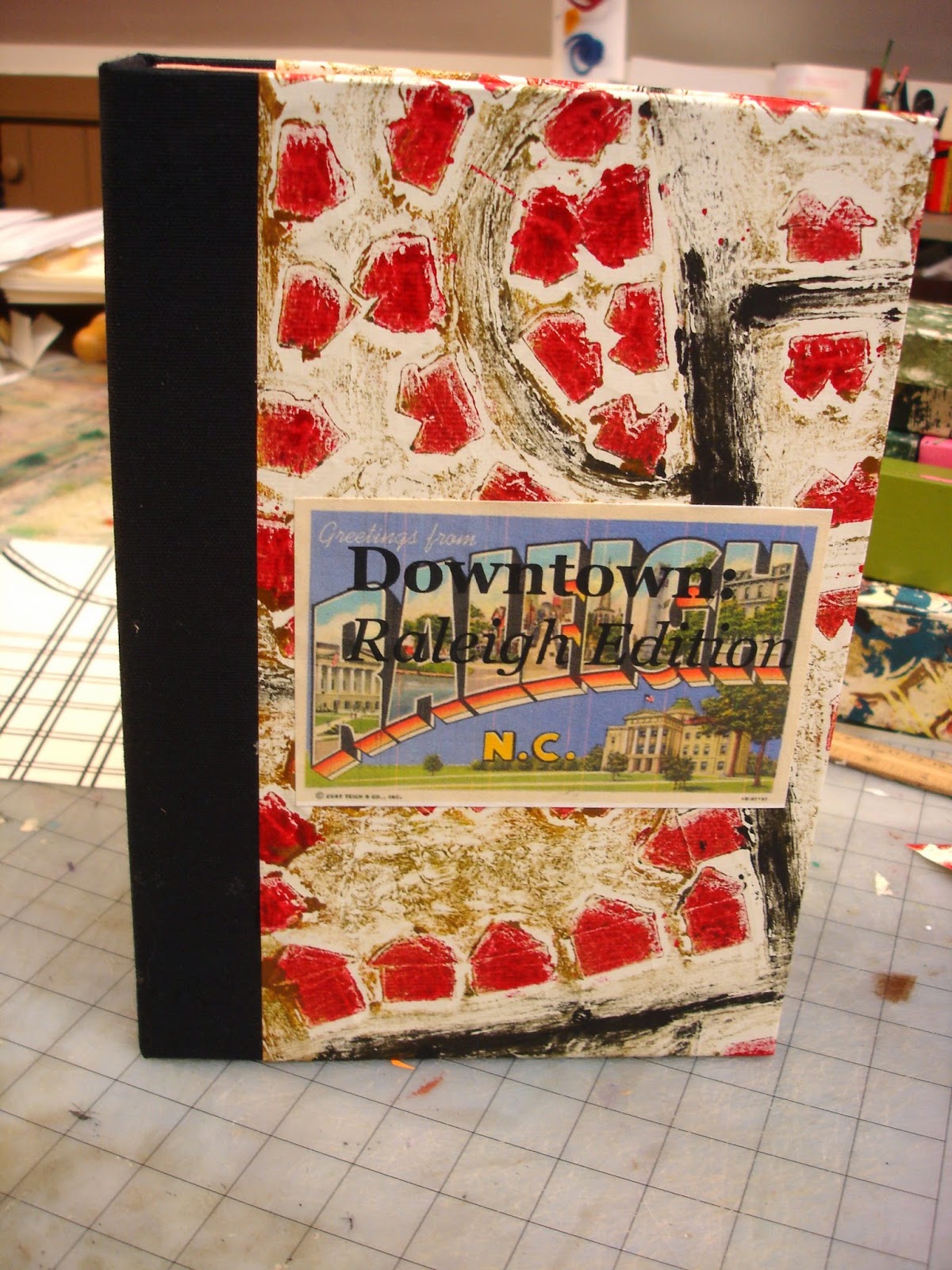
the bookish box that holds it all...
   The game is housed in a box that resembles a book. Black bookcloth stretches along the spine and a red and gold collograph print (titled Lyon Street) of a nearby Raleigh neighborhood surfaces the box lid and base. The title plate is printed on a replica of a vintage Raleigh large letter postcard, circa 1940.  Inside the box is the game board, a lifting board with a red satin ribbon pull, and a partitioned 4-section tray holding the other components of the game. The 4-section tray has a compartment for the tiny Where is it? cards listing every major street in the downtown area of Raleigh, many restaurants, and the major government and tourist attractions. There is a compartment for the rule book and two reference maps... for finding the places if memory doesn't provide the answer. There is a compartment for a Greetings from Raleigh N.C diary.... which is used to write any stories or anecdotes about places on the Where is it? cards... and there is a compartment for several writing pens.
the open box... tray with all the parts and game board underneath
   The map was hand drawn in pencil, outlined with Sharpie Marker, and then cut into 4 parts. Each image was burned onto a photopolymer plate so it could be letterpress printed onto Italian mouldmade paper. An edition of 5 maps were printed using the Vandercook press at Penland School of Crafts.

 
the 4 pages of the game board image
Identification of the streets and buildings was purposely left off the map so the Where is it? cards could be matched with their location on the map as the objective of the game. The cards are very small (about 1" x 1/2" at most) so they can be placed on the map as the game is played. The background of the Where is it? cards is the large letter postcard.
front side of the sheet of Where is it? cards... ready to be cut
Where is it? cards.... places on the map
All sorts of places are on the Where is it? cards.. The image below is one of the two artesian chocolate factories downtown... Yum! The diary is for writing about each place.. a visit or perhaps some urban legend about it... Did you know that three buildings in downtown Raleigh have nicknames? They are "Gotham," "Emerald City," and "The Starship Enterprise" ...these are also three of the Where is it? cards. The diary is great for keeping track of that sort of information...as well as personal impressions and memories, too.
Escazu Chocolate on N. Blount Street... 
No game is complete without a set of rules.... and how to win.
These are the rules...

1. Pick a Where is it? card from the pile.
2. Find it’s place on the game board. Get 5 points.
3. or, Go there and visit the place in person. Get 15 points.
4. or, Tell a story about the place and write it in the Greetings from Raleigh N.C. diary. Start the story  with the words: “Once I went...” Be sure to include your name. Get 25 points.
5. After all the cards are placed on the map (or whenever you set the stop time) the person with the highest points wins.
6. When not playing the board game, the Where is it? cards can be turned to their image side and put together as a jigsaw puzzle.


Included: 
Where is it? cards; 
Greetings from Raleigh N.C. diary;

Downtown Raleigh map; 

Downtown Raleigh Restaurants & Dining map; 

Writing pen

...the Downtown Rule book
After the game board was constructed, its measurement was used to make the tray. The tray base was cut first. It was sized to fit exactly on top of the folded up game board. Once the side walls were glued onto the base,  they were covered with a strong, but flexible, asian paper. Next, the placement of the compartment partitions was determined by placing all of the items inside the empty tray and making a pencil mark at the optimum partition points. After the three partition boards were cut and covered with the asian paper, they were glued into the tray.

Measuring the tray for the partitions placement...
The compartments' size were tested for accuracy, and then the inside bottom of the tray was covered with the decorative asian paper.
the tray in progress... with diary inside it's partition
After the tray was completed, its size was used to determine the size of the book-like box used to hold the entire game. The base of the book-like box was cut about 1/2 inch larger on all sides than the base of the tray (and folded game boards). The box sides were cut high enough to cover the stack of 1. tray, 2. game boards, and 3. the lifter board. Once the box was glued together and the cover paper glued on, the case for the book-like box was covered with bookcloth and the collograph print. Next, the box was glued to the back side of the case. Then, weights were temporarily placed inside the box to press the box onto the back board of the case and ensure there was a strong adhesion.
 
Making the book-like box case... weights inside the box
Finally, everything was placed inside the box for safekeeping and ready retrieval... when it's time to play Downtown: Raleigh Edition.

the open box with the gameboard folded up inside and the full tray laying beside it
The Raleigh skyline... which one is Gotham?

Raleigh skyline looking north from Hwy 401 across MLK Blvd. bridge

Monday, February 9, 2015

Week 6: Mapping Penland


   Week 6's book is titled Mapping Penland: A Sunday to a Sunday. It is the diary of an artist during one week at a remote artist retreat... illustrated as a map and a compilation of lines. 

The title and first Sunday diary entry..

The text was typewritten on the computer and printed with an Epson inkjet printer. The map was hand drawn with a Sharpie Marker. Colored Sharpie Markers were used for the lines depicting movement from place to place. The colored markers were matched with the day of movement. A Legend was added to the map, showing which line color corresponded to which day.
Legend of line colors of the days
the whole map..

The book was folded as a commercial map might be folded... the text is viewable on the outside and the hand drawn map is on the interior.

Monday-Thursday

An excerpt of Monday's entry...

Monday: Awoke to my phone alarm tinkling at 8am; took a shower and headed up to Northlight for the 9am introductory meeting with Jerry. Sat with Gail, and Edwina comes in and joins us. After the meeting, spend an inordinate amount of time trying to decide about coffee... should I buy it at the Coffeehouse for a dollar? should I make it at Young House...(my assigned cooking house)? should I make it at my living house, Radcliff? should I make it in the studio? I decided to make it at Young House. ..Filled the coffeepot and it didn’t work. Moved it to the other side of the room. It still didn’t work. I took the coffee bag, the full and damp filter, my cream... and head to the studio. Jay and SaraBeth say they are making coffee for everyone before our 10am safety meeting, so I add mine to theirs... eventually I get my coffee. I met Ursula who teaches at Towson College in Baltimore and is working in the Print studio; I met Rebecca who is in the Letterpress studio with me and is a graphic designer in Charlotte; Jay leads the 10am safety meeting then shows Rebecca and me how to use the photopolymer platemaker and the computers. I move my stuff around and get situated into my two desk(s)... they look at the watertower and are the closest to the new bookstudio construction (lovely!!); I get out my stiff paper (Lenox?) to make more cards for The Gates game... I decide to start with pochoir of the background; I go to the school store to get supplies...no stamping inks are there but I get: two sponges to apply the inks or paints for a “stamp pad”, a glue brush for the pochoir, and a (totally random) tiny metal triangle; I go back to the studio and since I have Margaret Cogswell’s book I decide to use acrylic paints for the pochoir instead of inks... ugh.. really dry... I finish all 5 sheets.. but hate the look and the other person working in the room has music playing that is really annoying... so I go back to my room for earplugs; decide to have breakfast/lunch since it’s 2:30 now.. lay in bed and play computer games and eat the leftover cabbage, apples and kielbasa... read, more games, check facebook, write some emails... (to Diann and Flea), I’m so tired. I never go back to the studio...or get out of bed, eat peanut butter and jelly sandwiches in bed for dinner and then snack on pbj with no bread; turn out the lights between midnight and 1am.


The coffee maker...
Pochoir....
Later in the week... the diary entries get shorter.. is this because more work is being done?


Friday to Sunday...
The movement still continues pretty heavy between Radcliff, the Letterpress Studio, and the School Store...

concentrated triangle: studio-Radcliff-car-Young House...
Many maps have Points of Interest... in this case, Room #9 Radcliff, was quite important.
Upper right window: the room
... and The Watertower... directly in front of the artist's desk...
the watertower...view from the desk
A close-up view of the Letterpress Studio, the Print Studio, and the community gathering place at Young House shows a fluidity that resembles a river.

Letterpress studio and Young House
The nearby creek... bubbling and tumbling over rocks, around curves and through the woods... is always in motion... just like the artist in Mapping Penland.

creek trail

Monday, February 2, 2015

Week 5: Flood Gates

   Antique maps are intricately beautiful works of art. Seeing a landscape pared down to lines and grids has a way of making it more intimate while also expanding it's scale beyond the realistically visible. With some imagination, these maps tell a story. This week's book, Flood Gates, is an altered form of a previous book-of-the-week, Week 25, 2014, Flood Gates (http://paperbuttons.blogspot.com/2014/06/week-25-flood-gates.html). The current Flood Gates is set in a specific place, the Mississippi River... after the Great Flood of 1927. The poem is a letterpress-printed broadside over a copy of the historic 1927 map of the flooded areas and relief operations.
the entire broadside, 18 x 7 inches
    Below, is an image of the original map of the Flood and Recovery Field Operations drawn by the US Coast and Geodetic Survey for the Red Cross and the Secretary of Commerce, Herbert Hoover. A closer view can be seen on the link: 1927 Mississippi River Flood.
original map, Records of the Coast and Geodetic Survey
   The Great Mississippi Flood of 1927 affected 7 states (Arkansas, Illinois, Kentucky, Louisiana, Mississippi, Missouri, Tennessee, Texas, Oklahoma and Kansas) and was the most destructive flood in the history of the United States. John M. Barry describes the flood and its destruction in his book,  Rising Tide: The Great Mississippi Flood of 1927 and How It Changed America. Over 250 people died, hundreds of thousands of people were displaced, and over 27,000 acres were flooded after the river rose and over 145 levees broke. 

   An unusually wet summer in 1926 led to a swollen Mississippi river and tributaries in Iowa and Kansas overflowing by September. On Christmas Day, 1926, the Cumberland River in Nashville, Tennessee was at 56 ft, still the highest point ever. On April 15, 1927, Good Friday, rains began falling over Missouri, Illinois, Arkansas, Mississippi, Texas, and Louisiana. In New Orleans, they were recorded to have lasted for 18 hours. All along the river, people worked to build up the levees. On April 21 the first levee broke at Mounds Landing, Mississippi. Waters rushed through the three quarter-mile crevass at the same force as the waters of Niagra Falls. Flooding extended 60 miles east and 90 miles south. Over 185,000 people were displaced from this area alone. A PBS documentary describes the flooding and human conditions in Greenville, MS near Mounds Landing (PBS Documentary). In addition to the property destruction was the tragedy of human condition and reaction towards the African American population during the flooding and recovery period. A large exodus of the African American population out of Mississippi and into the Northern cities followed... National Geographic describes the flood and some of the outrageous choices in its article,  Man vs Nature.
Mounds Landing levee breech, 1927
   Though all floods are catastrophic, this particular flood map seemed most appropriate to cover all of the untold stories behind the words of the poem, Flood Gates. The map was inkjet printed onto Rives BFK paper with an Epson printer. The typeface used for printing the poem was 14-point Bembo and the poem was printed on a Vandercook letterpress at Penland School of Crafts in Penland, North Carolina. Ink color was selected from the Pantone Color Guide to match the river on the original map.
choosing an ink color from the Pantone color guide...
Ink was mixed on a glass plate and then applied to the cylinder rollers of the press for even printing.

mixing the ink
Once the ink was ready, the type was locked into the press bed. To repeat imagery of the two banks of the river, the stanzas were set in two columns. The lines of the poem were set with uneven margins to repeat the convoluted shape of the river. The uneven margin typesetting process was quite fun for this book artist.. and is highly recommended as a letterpress exercise!
lines of type in the pressbed
Printing was begun just below the title and legend of the original map.
titles, map and poem
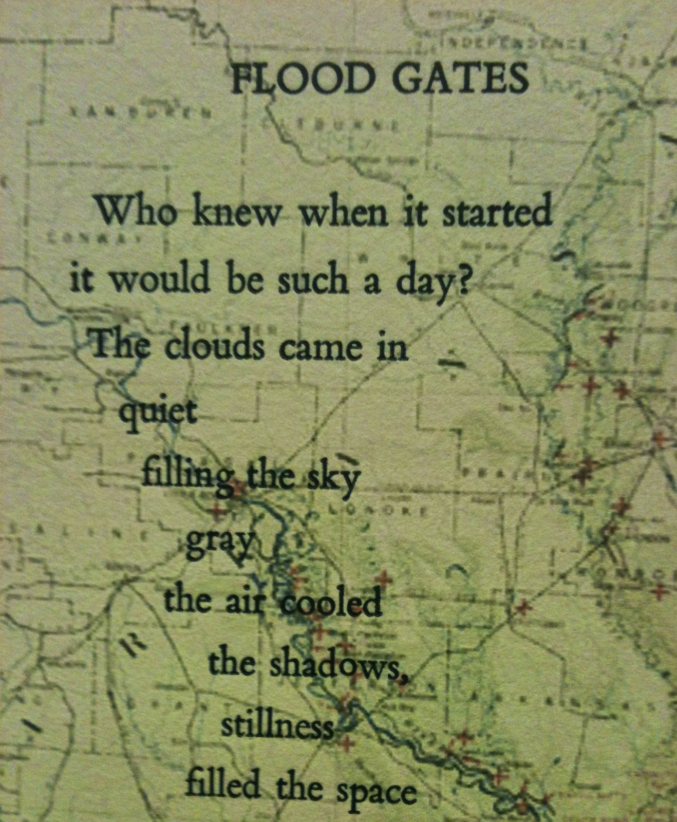
The poem begins with the title and first stanza on the left...
the first stanza..
the lines of the poem move like the river...

meandering lines of type.. like the river
and the river is soon bordered by two lines of type...

the poem.. on two banks
and converge at the bottom part of the poem.
moving along the river way...

This is the poem.
 Flood Gates

Who knew when it started
it would be such a day?
The clouds came in
    quiet
      filling the sky
           gray
         the air cooled
              the shadows,
                    stillness
         filled the space

In the distance thunder
  rumbled...
      electricity
  moved through the air
as if the gods were whispering
 their heavenly
       beware.

 The first drops 
        fell
 big and sloppy
playfully splattering,
     plopping and pinging
         the sidewalks and lawns,
      forests, highways,
   and farms

    Meanwhile the thunder
  grew louder,
its growl more insistent
        with snap cracks
                of lightening
      that startled the nerves
  frightened the little babies
...and the old folks too.

The wind blew the rain
        sideways
    sent hats a-flying
and umbrellas turned
    upward
      like tea cups scared stiff

     Then the rain came in
  sure and drenching...
pouring sheets and sheaths
             that were flapping and waving
                like clothes on the line...
          washing away the refuse,
 the dust and the grime

           So the drivers slowed down
             it was that hard to see
 and the walkers took shelter
on porches, and in doorways,
    under bridges, and trees
          looking for cover
             as quick as could be.

  Still the water
 kept coming
             the rain never ceased...
         the torrents above
      and the deluge below

     It was a world washed
in wetness
 ...the sky gods were weeping
         and everything not sheltered
was soaked, sodden, or
                   floating...
            and the mud just
          kept rising
    because
the flood gates
        had opened.

 Who knew
     when it started
    it would be such
      a day?
Lake Village, Arkansas, 1927